
All around Okuwa village are mountains, in which Mt. Itose is special. It is one of the Kiso Three Mountains and it represents Okuwa village. It is between the Kiso River and the Central Alps. Therefore, Mt.Itose can be seen from any peaks of the Central Alps.

On May 22, I climbed Mt. Itose. The start of the trail up to Mt. Itose is at the middle of the Matsubuchizawa forest road. On the map, the trail starts at the Suhara station but less people use the path between the Suhara station and the start of the trail.

The start of the trail is an enterance to the forest and a steep trail begins.


The course time of the trail up to the top of Mt. Itose is 3 hours 35 minutes climbing about 1,000m and down is 2 hours 35 minutes.There are many steep paths but the fresh air, beautiful flowers and songs of birds gave me right steps.


Just before the top, you can see the Inagawa-dam below. Also, you can see mountains of the Central Alps if you are lucky.


On the top, there is a huge rock named Noroshi-Iwa or the rock of signal fire. There is a rudder but it is uneasy to reach the top, where a lookout platform is available. Since I’m not good at a higher place, I gave it up. Those who have enough skill and courage can see the Central Alps there.


There places on the top are big trees and rocks and less flat spaces and less view either. If the trees would be cut down, I’m sure we could have a great panoramatic view of the Central Alps.


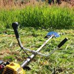
There is no dangerous point on the way and I was safely back to the start, where my mini-track was waiting for me as usual.

Climing Mt. Itose is really fun. Highly recommended.
コメント